I have said this before and I said it a few weeks ago when I was panting on a path in Beacon Rock State Park figuring out that I wasn’t having any fun (although the views were beautiful). Never trust the ranger or the guide book when you want to know how easy a hike is. Guides are written by people who are in good shape and hike regularly. But what if, like me, you would like to enjoy the outdoors and get into better shape but just aren’t right now? I’ve been told a hike was easy and ended up feeling as if they were going to have to fly me out with a helicopter.
So, I decided to do something about it, and what I am doing is publishing this site, a guide for beginning hikers or people who are just out of shape for hiking in Southern Washington and Northern Oregon.
And here’s my rating system:
Easy peasy: this hike is mostly flat and footing is not too rough; anyone should be able to do it.
Easy: this hike has some ups and downs or may be a little rough, but is easy for most hikers.
Middling: this hike is rough or has some elevation changes, but you can do it.
Moderate: this hike may have more elevation changes or be more rough; if you have mobility or stamina problems, you might want to work up to this one.
I probably won’t being going on any more difficult hikes at this time, so I will add levels to the rating system accordingly.
And now, let’s get on to the first hike.
Salmon-Morgan Creek Natural Area
 Rating: Easy peasy
Panting stops: 0
Length: 1.3 miles
Elevation changes: 65 feet
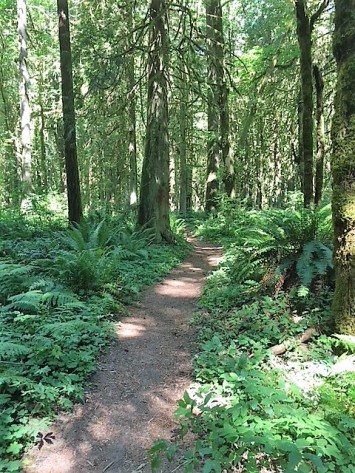
This trail takes you into a beautiful forest of old-growth cedars. It begins in a residential area, but once you walk into the forest, there is almost no hint that you are so close to a neighborhood. It has nicely kept trails.
There are two loops, the Fir Loop Trail and the Alder Loop Trail. If you walk them both, they total 1.3 miles. There are a few offshoots that go to views of the river and one unofficial trail that takes you to the railroad. The path is mostly well-marked, but you may end up at the railroad by mistake. At the junction, look for the path marker to figure out which trail is the “official” one. The area is peaceful with moderate traffic by other hikers.
I was first here in the late winter/early spring, and at that point it was very muddy in places. I recommend this trail anytime after it has had time to dry out a little. I was just there this week, and it is perfect. It is very wooded so provides lots of shade during hot weather.
How to get there
NE 161st Ave., Brush Prairie, Washington
This particular park does not show up on my car’s GPS. It does show up on the All Trails app.
From Vancouver
Take SE 164th Avenue north until it turns into NE 162nd Avenue. Continue until the end of the road and then turn left onto Ward Road. Keep right to turn onto Padden Parkway. Turn right on 152nd Avenue and follow for a few miles, then turn right onto NE 181st Street. Turn left on NE 159th Avenue, and then right or left onto NE 183rd.
From Battle Ground
From Main Street, go south on SE Grace Avenue, which becomes NE 142nd Avenue. Turn left on NE 159th Street, where 142nd ends. Turn left on NE 152nd Avenue and then turn right onto NE 181st Street. Turn left on NE 159th Avenue, and then right or left onto NE 183rd.
Parking
There is parking at the west end of NE 183rd or at the end of NE 161st. Please be aware that you are parking in a neighborhood. If there are several cars parked there already, go down one of the other streets to find a parking spot.
